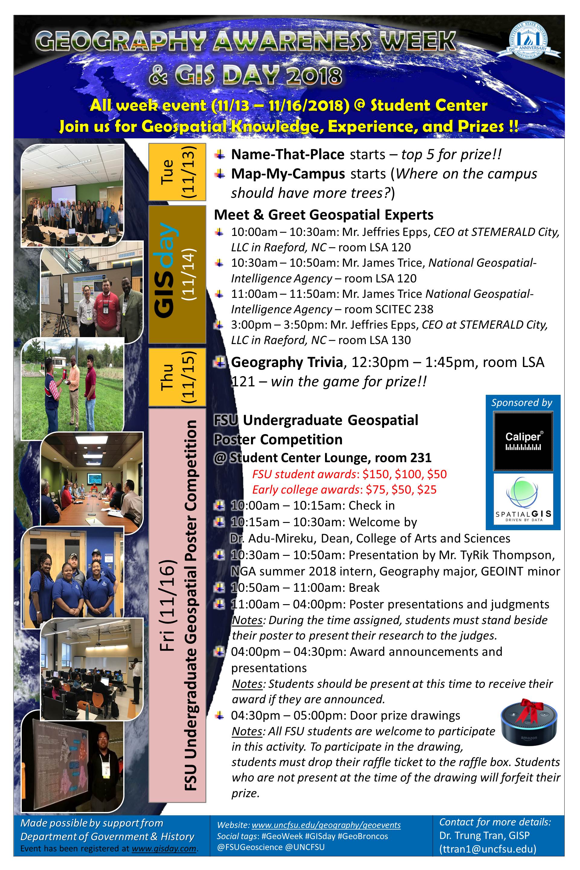
GeoWeek and GIS Day 2018
Geospatial Sciences B.A. | GEOINT certificate | Geospatial News | Geoscience Student Association
If you plan to participate in the FSU Undergraduate Geospatial Poster Competition with a poster presentation, please make sure that you read the guidelines as well as register for the presentation using the registration form below.
CALL FOR PARTICIPATION IN FSU UNDERGRADUATE
GEOSPATIAL POSTER COMPETITION
1st place: $150 | 2nd place: $100 | 3rd place: $50
The Geography program in the Department of Government and History at Fayetteville State University invites all FSU undergraduate students from all majors, which should not be limited to Geography major, to present their research project that utilizes or produce geographic information at the FSU Undergraduate Geospatial Poster Competition. The top three posters will be awarded with monetary prizes. Guidelines for the posters are below.
Who should attend this competition? All FSU undergraduate students from all majors.
Where to present your poster? The student lounge in the Rudolph Jones Student Center.
When to present your poster? The competitors must stand by their poster to present their poster to the judges at one of time slots given in the online registration form. Confirmation of the time will be given by the event organizer.
What to present? Students should present any kind of research project that they have completed, which can be a class project that utilizes or produces geographic information. However, please note that the project must be advised by an FSU faculty.
How large is the poster? The poster should be 24 x 36 in. Participants will attach their poster on a foam board placed on an easel in the student center. The foam board and easel will be provided by the event organizer. However, students must return the board and easel to the organizer when they are done by 5:00 pm on Friday (11/16).
How to participate?
Step 1: Register your poster abstract online in the form below by 11:59pm on Monday (11/12/2018).
Step 2: Make sure that you have your poster set up in the student lounge by 2:00 pm on Thursday (11/15/2018) for the judges.
Step 3: Be at your poster at the time given by the organizer to present your poster to the judges. Check your email for the time.
CALL FOR PARTICIPATION IN FSU UNDERGRADUATE
GEOSPATIAL POSTER COMPETITION
Early College Students - 1st place: $75 | 2nd place: $50 | 3rd place: $25
The Geography program in the Department of Government and History at Fayetteville State University invites early colleges students from Cumberland International Early College High School and Cross Creek Early College High School to present their research project that utilizes or produce geographic information at the FSU Undergraduate Geospatial Poster Competition. The top three posters will be awarded with monetary prizes. Guidelines for the posters are below.
Who should attend this competition? All early college students from Cumberland International Early College High School and Cross Creek Early College High School.
Where to present your poster? The student lounge in the Rudolph Jones Student Center.
When to present your poster? The competitors must stand by their poster to present their poster to the judges from 2:00 pm to 4:00 pm on Friday (11/16).
What to present? Students should present any kind of research project that they have completed, which can be a class project that is about the Earth.
How large is the poster? The poster should be 30 x 20 in. Participants must bring the printed poster to the lounge to set up by 2:00 pm on Friday (11/16).
The Fun Side of Cartography by Leah Holt
Research advisor: Dr. Tran, Col. Lee
Abstract: This map will take a quick look at Ireland (officially known as the Republic of Ireland) in order to highlight areas best suited for skydiving. There is no real hypothesis, but the result is expected that the drop zones will coincide with smaller, rural and perhaps private airports/runways which will be located in less urbanized areas. The importance first fold is of a personal nature so that the author may continue with the hobby of skydiving upon returning to her home country but second fold to highlight how mapping can be readily used for such an individual personal topic.
Presentation time: Friday (11/16/2018), 11:00am - 12:00pm
Hate Crimes and The Election by Gemini Moore and Alfie Frederick
Research advisor: Dr. Tran
Abstract: In the height of election frenzy, some would argue that there is an alarming trend being highlighted in the growing number of hate crimes committed in the United States. This begs the question of what has been influencing these hate crimes. There was not enough data to associate hate crimes with hate groups for the four presidential terms we assessed, but there was data to suggest that there was a correlation between hate crimes and the political affiliation of the inaugurated president.
Presentation time: Friday (11/16/2018), 10:00am - 11:00am
USA Air Pollution by Tyrek Clark
Research advisor: Dr. Tran
Abstract: I will be presenting the Air pollution in the USA for CO2 emissions from coal, natural gas, petroleum power plants and transportation and industrial emissions. I will also compare years before major laws were enforced to remove CO2 from power plants emissions.
Presentation time: Friday (11/16/2018), 10:00am - 11:00am
Human Trafficking by Kyle Brown and Alyssa Price
Research advisor: Amy
Abstract: Human and Sex-trafficking is the modern-day slavery that involves use of force, fraud, or coercion to receive labor or sexual act (2018). This is a hidden crime where many victims do not seek help due to language barriers, fear of the traffickers, or the fear of law enforcement. Each year, there are millions of women, men, and children that are trafficked in the United States and even in Fayetteville, North Carolina (2018). Estimates have proven that human and sex-trafficking produces more than a billion in profit per year and is second to drug trafficking as the most profitable transnational crime (2018). Fortunately, with the help of law enforcement, analysts, and ArcGIS human and sex-trafficking data can be illustrated for citizens to become informed of the location and occurrences of the crime around them.
Presentation time: Friday (11/16/2018), 02:00pm - 03:00pm
The Second Sino-Japanese War- Battle of Shanghai by Jadon Ormond
Research advisor: Dr. Pash
Abstract: My presentation will be on the 1937 Battle of Shanghai, which occurred during the Second Sino-Japanese War. The battle was notoriously brutal, filled with street-to-street, house-to-house fighting, and can be compared to the brutal horrors in Stalingrad during World War II.
Presentation time: Friday (11/16/2018), 10:00am - 11:00am
Life and Campaigns of Oda Nobunaga by Andrew Thetford
Research advisor: Dr. Pash
Abstract: A visual representation of the campaigns of Sengoku era Daimyo Oda Nobunaga. Starting with his consolidation of power in Owari province to his death at Honnō-ji.
Presentation time: Friday (11/16/2018), 02:00pm - 03:00pm
Aqueduct Water Stress in the United States by Ramona Gill Herring
Research advisor: Mrs. Bennett
Abstract: The “Aqueducts in the United States" (U.S.) are designed as distribution systems to tunnel surface fresh water from rivers. The Earth has about 2.5% of fresh water, mostly in the ground and ice for life to survive. Surface fresh water is about 1.2% and rivers make up approximately 0.49% is where the U.S. where a large portion of water for human consumption comes from to supply in many aqueducts. The clean drinking water or water access and the available flow of water to aqueducts is under stress. The amount stress is due to water withdrawal total supply; public supply 12%, domestic, livestock and aquaculture mining 5%, irrigation 37%, thermoelectric 41% and industrial 5%. (4) The media coverage(MC) shows all media articles about water scarcity and pollution in various areas. Base line water stress displays the total annual withdrawals and available flow with the higher percentages due to competition of agricultural, industrial and municipal water usage. (2)
Presentation time: Friday (11/16/2018), 11:00am - 12:00pm
Bigfoot sightings Compared to Population Density of Humans by James Duncan
Research advisor: Dr. Tran
Abstract: During research, an observation was made that the number of sightings of Bigfoot tended to be higher as expressed in a ratio of humans living in the area per square mile in compared to the number of sighting. The poster was designed to show if the observation was accurate by constructing a spatial analysis of both the human population density across the contiguous United States and Alaska and the density of sightings of Bigfoot.
Presentation time: Friday (11/16/2018), 11:00am - 12:00pm
Spatial Pattern of Crimes in the City of Fayetteville (NC) in 2017 by Corey Bissen
Research advisor: Dr. Tran
Abstract: The aim of this study is to determine the locations in Fayetteville, NC that has crime and the amount of crimes that happen there. Crime has risen in the city of Fayetteville over the past couple of years due to many problems. Problems that seem the occur in Fayetteville are assaults, burglary, and shoplifting. Just these three crimes alone make up 75.3 Percent of crime in Fayetteville. This raises concern in the city as it grows in size and is expected to grow in population. These crimes were committed where infrastructure were not well-maintained, but there are places with high crime that have great infrastructure. After seeing these results it means that it doesn’t matter where you live. There can be higher amount of crime even in a great housing area. Fayetteville could look into putting more patrol cars in these areas to try to decrease the crime rate.
Presentation time: Friday (11/16/2018), 10:00am - 11:00am
Homelessness in America by Kiana Williams
Research advisor: Dr. Tran
Abstract: The purpose of this study is to map the amount of homelessness in the United States of America. In addition to that, I will also be mapping the amount of available homeless shelters across the country. In the United States, there are currently 744,313 people living on the street. I would like to use this information to get the number of people living on the street down and the number of homeless shelters up.
Presentation time: Friday (11/16/2018), 11:00am - 12:00pm
Violent Crime in U.S. Increases Near Illegal Routes in Mexico by Christina Rodriguez
Research advisor: Dr. Tran
Abstract: The maps are about the who, what, where, and how’s of drug trafficking flows and the violent crimes associated with and/or exacerbated by them. Flows of illicit activities, in large part drug related, enter the United States, through the U.S. Mexican border. Violent crimes follow transnational organized crime (TOC
Presentation time: Friday (11/16/2018), 02:00pm - 03:00pm
The FSU 2018 GeoWeek and GIS Day is sponsored by Caliper Corporation and SpatialGIS LLC.
|
Caliper Corporation founded in 1983 and headquartered in Newton, MA, is a technology leader in the development of GIS and transportation software. Caliper is also a highly regarded consulting and R&D provider offering professional services in quantitative management consulting, transportation, and decision support systems development. Caliper software products are supported with extensive technical services in GIS applications and training, database development and software customization. Caliper is the developer of TransCAD® Transportation Planning Software, TransModeler® Traffic Simulation Software, and Maptitude® Mapping Software & Geographic Information System. |
 |
|
|
SpatialGIS is geospatial consulting firm founded by Kendrick O. Faison, M.S. GSci. Mr. Faison developed the company’s core services based around his more than 13 years of Geospatial and Emergency Management experience. SpatialGIS is a solution-focused company that specializes in supporting federal, state, local and commercial clients. SpatialGIS consolidates industry standards and develops a rapid geospatial team for all emergency situations along with agile development practices that gives us a competitive edge. |
 |

